The History of Alexandria Louisiana
The Early Years
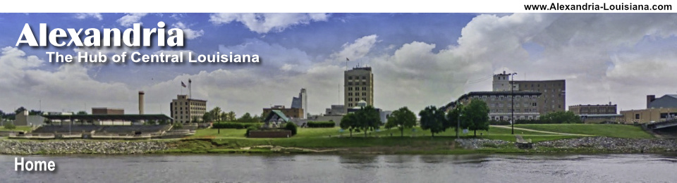
The present site of Alexandria was a natural one for settlement due to its location on the Red River in Central Louisiana. It lies on a level plain of Longleaf Pine forests at 55 feet above sea level, in almost the exact geographic center of Louisiana.
 Map of Alexandria circa 1872 |
The area was originally home to a community supporting activities of the adjacent Spanish outpost of Post du Rapides. Ultimately, Alexandria would became the parish seat of Rapides Parish.
A community of traders and merchants lived and worked in the agricultural lands bordering the mostly unsettled areas to the north, and providing a link from the south to the El Camino Real and then larger settlement of Natchitoches.
Alexandria was then platted by Alexander Fulton, who obtained it as a land grant from Spain in 1785. Fulton, a Pennsylvania trader, purchased additional land from the Choctaw, Tensas, Appalachee and Pascagoula tribes through his store.
Fulton and another trader, William Miller, established a business across the Red River from the outpost, and were given exclusive rights with the Indians. They were authorized to extend credit, and when the Indians could not pay their bills with their exchange of furs, they signed over lands to cancel the debts. Fulton and Miller thus acquired thousands of acres that they then resold to settlers who were attracted to the rich lands along Bayou Rapides, Bayou Robert and Bayou Beouf in the Alexandria area.
Fulton laid out the plan for Alexandria in 1805, and the settlement grew rapidly. Because of its strategic geographic location, which still holds true today, it became a center of transportation, trading and agriculture.
The origination of the city's name of "Alexandria" is still a fact for history to decide. Some historians claim it was named after Fulton himself. Still others believe that Fulton named the town after his infant daughter who died about the time the town was platted.
The town was first incorporated on March 18, 1819, and received its official charter from the Louisiana Legislature in 1832.
The Importance and Role of the Red River
 Cotton packet on the Red River in Alexandria, circa 1800s (Louisiana History Museum) |
The Red River of the South meanders 1,360 miles through Texas, Arkansas and Louisiana before emptying into the Mississippi River. It forms the border between present-day Texas and Oklahoma for significant distances.
The Red River has played key roles in Alexandria and Pineville through the decades, and centuries, through peaceful times and through the Civil War, through low stages of the river, and during floods.
The river was not navigable above Alexandria for many months each year due to the rapids. For practically half of the year (from July to January), Alexandria was at the head of navigation on Red River.
During this time, boats could not ascend above this point due to the rapids in the river. All cargoes had to be transported by land around this impediment and re-shipped. In some seasons of the year, the upper river was so shallow that boats could not make the trip. As a result of this condition, a number of warehouses were built to store goods moving from South Louisiana to Western Louisiana and Texas. Alexandria's namesake "Rapides Parish" is derived from "the rapids".
The merchants who owned these warehouses purchased the products that were brought overland to this point and supplied the planter and trader with the necessary goods.
Alexandria Burned Down: The Red River Campaign in the Civil War
During the Civil War, the town twice suffered the ravages of Federal occupation. In the spring of 1863, Alexandria was occupied by Union forces. On May 13, 1864, when the Union decided to abandon Alexandria, the city was set afire, and 90% of the own burned in what became known as the Red River Campaign.
 St. Francis Xavier Catholic Cathedral |
The Episcopal and Methodist churches were also burned by the Union forces, as well as every building on twenty-two blocks. Many libraries, plantations, businesses and residences were also destroyed during the campaign.
The only church that was left standing was the Catholic church, now known as St. Francis Xavier Cathedral on Fourth Street (see photo to right).
The war was also the time of the construction of Bailey's Dam, near the now-razed O.K. Allen Bridge, by Lt. Col. Joseph Bailey of the Union forces, in April-May of 1864. Bailey was the engineering officer in charge of operations.
The dam allowed for deepening of the Red River at the rapids to permit passage of deep-water gun boats, including the Mound City and the Carondelet, escaping from the disastrous defeat at Mansfield, but stopped by low water above the rapids.
Alexandria in the Late 1800s
Alexandria was in the center of massive native forest lands, much of which would ultimately be included in the Kisatchie National Forest. The growth of the lumber industry in the latter years of the 19th century and the opening of the area by the railroads allowed Alexandria to prosper immensely.
The golden age of the “sawmill capital of the world” was dawning, with 75 mills operating within 40 miles of Alexandria. Alexandria retains its connections to the timber industry to this day, with several sawmills and related industries such as the Roy O. Martin Lumber Company.
The Railroad Comes to AlexandriaAlexandria, situated in Central Louisiana, at the virtual crossroads of Louisiana, quickly became a major railroad center. Among the railroads that have served Alexandria:
Read more about Alexandria Railroads.
Vintage Postcard of the Union Depot, Jackson Street and Tenth Street, Alexandria, La., completed in 1909 |

The Early 1900s in Alexandria
 Alexandria Louisiana City Hall |
Rapides Bank & Trust Company constructed its building in 1898 at the corner of Murray and Second Street. Across the street, a new Alexandria City Hall was built in 1909 to house an expanding city government. It was located on the block between Second and Third Street, between DeSoto and Murray.
The new city hall featured a square footprint, on raised ground from street level. It was built of tan brick and concrete, with Ionic columns supporting pedimented porticos on each of the four sides. The dome was covered with red tile. The building was demolished in the early 1960s to make space for a "modern" city hall and convention center.
The population grew, and new schools such as Bolton High School, Menard Memorial High School, and Providence Central Academy were built. The automobile arrived, and streets began to be paved. Electric trolley service was provided around the city.
 Streetcar Number 3 of the Alexandria Electric Railway Company, pre-1915 (Photo courtesy of the Louisiana History Museum) |
 The Murray Street Traffic Bridge |
The first bridge across the Red River was completed in 1902, the Murray Street Bridge. A two-lane steel truss swing bridge, it remained in operation until demolished in 1983 and replaced by the Gillis Long Bridge at Jackson Street.
In 1912, a commission form of government was adopted by the Legislature which provided for the election of a Mayor, who also served as Commissioner of Public Health and Safety, a Commissioner of Streets and Parks and a Commissioner of Finance and Utilities.
The building of Camp Beauregard near Pineville started in 1917, when the War Department authorized more than thirty such camps around the country to train troops for World War I.
The camp was abandoned after the war in 1919 and given to the state, but returned to the U.S. Army during World War II; today, it serves as a base for the Louisiana National Guard along with Esler Field.
The Alexandria Public Library
 Alexandria Public Library |
The Alexandria Public Library opened its new building in 1907. The building was constructed solely for the advancement of culture and learning in by Caldwell Brothers (contractors), and Crosby & Henkel of New Orleans (architects). It replaced an earlier library that was burned by General Nathaniel Banks' federal troops on May 13, 1864.
Remodeled in 1970, restored as a Bicentennial project in 1976, and again in 2003, it now houses (upstairs) one of the largest genealogical libraries in Louisiana.
It was placed on the National Register of Historic Places in 1989. The Louisiana History Museum occupies the downstairs area, and features over 50 displays from prehistoric time till now.
The History of the Hotel Bentley
The Hotel Bentley, built in 1908, was the namesake of Joseph A. Bentley. Bentley was a local lumber mogul who had moved from Pennsylvania, by way of Texas, to Rapides Parish in 1892. James F. Litton was the first hotel manager.
The Hotel Bentley was built by the F. B. Hull Construction Company of Jackson, Mississippi on Third Street one block north of the Alexandria City Hall.
As the “flagship” hotel of Central Louisiana (CenLA), the Hotel Bentley was to experience visits during World War II and the Louisiana Maneuvers by several military notables.
 |
 Guaranty Bank & Trust Company |
These included Major General George Patton, Lieutenant Colonel Omar Bradley, and then not-so-well-known Colonel Dwight David Eisenhower. Generals George C. Marshall and Matthew Ridgeway are said to have visited the Bentley also, as well as then-little-known Second Lieutenant Henry Kissinger.
Entertainers also stayed at the Bentley, many of whom performed for the troops during WWII.
Cowboy legend Roy Rogers stayed at the Bentley during the 1950s during a trip down the Red River. And John Wayne spent several nights in the Bentley during the filming of the movie "The Horse Soldiers" near Natchitoches. Remodeled and renovated, the Hotel Bentley remains open today.
The 1920s: Buildings and Banking
Following Paul Lisso’s death in 1911, Joseph A. Bentley was elected president of the First National Bank.
Expansion plans were being formed in 1918 for a ten story office building and the ground breaking was held on February 28, 1919. The architect was Emile Weil, and T.S. Moudy and Company of Chattanooga, Tennessee was the contractor.
The $750,000 structure provided 6,000 square feet of space for banking functions. By 1920, bank resources had reached over $5,000,000. Early in 1921, stockholders voted to change from a national bank charter to a state bank charter; this obviously called for a name change and Guaranty Bank and Trust Company was the name selected.
The “City Savings Bank and Trust Company,” originally a sister institution to the “First National Bank,” was absorbed into the Guaranty Bank at the time the latter facility was reorganized under a state charter. Shortly thereafter, the new Guaranty Bank Building was completed.
Alexandria in the 1930s: The Lodging Industry EvolvesIn the 1930s, as automobiles became a more dominant and affordable means of transportation, tourist courts were built, offering the privacy and comfort of a one-room accommodation. Whether they were called courts, cottages, cabins, or lodges, they offered similar amenities. There was the Edmary Hotel Court, Parkway Court, Ransville Courts, Strube's Hotel Court, Willow Glen Courts, Colonial Court on North Bolton, and others around Alexandria. Gradually a newer, but similar, concept evolved: the "motel", a cross between an auto motor court and the traditional downtown hotel.  Judie's Motor Court, north of Alexandria on Highway 71 |
Residential Growth in the 1930s
Alexandria was growing, to the west, out Monroe, Elliott, and Jackson Streets, across Chester Street, and towards Texas Avenue. New homes were built in places like Alma Street, and in new developments such as Crawford Edition, Poplar Grove and Hillcrest.
Some of the family names we recall from that period: Freeman, Baker, Webster, Dantin, Waddell, Watson, Pourcy, Kirkland, Texada, Cowart, Timmer, Berlin, Walker and Tunney. The men in those homes worked throughout the city, at Metropolitan Life Insurance Company, Weiss & Goldring, the railroads, banks, the city power plant and other local businesses.
A typical house in that area was built in 1937, on a lot 50 feet wide and 150 feet deep. It was expanded in later years to three bedrooms and 1,530 square feet of space!
New Structures in Downtown Alexandria |
|
New U.S. Post Office, circa 1933 |
New Rapides Parish Courthouse, circa 1940 |
World War II in Alexandria and Central Louisiana
 Louisiana Maneuvers sign, outside Hotel Bentley |
Changes and impacts abounded in Alexandria as another world war grew closer to the United States.
Alexandria and Central Louisiana were the site of the massive Louisiana Maneuvers staged just before World War II. Numerous military camps were built in the CenLA area to support the growing war effort: Camp Livingston, Camp Claiborne, Camp Beauregard, Esler Field, Pollock Army Air Field, Alexandria Army Air Base, and others.
Suddenly there was a shortage of many of the basics of life, and a system of rationing was inaugurated. Families were issued ration books with stamps good for certain items such as gasoline, tires, meat, and sugar.
In 1939 construction crews began to expand Camp Claiborne for its reactivation as a U.S. Army camp during 1940. It spanned 30,176 acres.
Within a 30-miles radius of Alexandria, the military also constructed Camp Livingston, Esler Field, Alexandria Army Air Base (later England Air Force Base), and reactivated Camp Beauregard. Camp Polk was located further west of Alexandria near Leesville.
Alexandria in 1940 extended only a few blocks west of Chester Street, and the outskirts of town were favorite places for the Army to set up their 155 millimeter cannon and anti-aircraft installations. Sometimes soldiers would permit children to peek through their range finders and climb all over the cannons. Occasionally, opposing forces would engage in a battle and children would fill their pockets with spent blank rifle cartridges.
Except for Camp Beauregard, all of the army camps and air bases closed soon after the end of the war. England Air Force Base based emerged again in the 1950s as a significant military post.
The economy suffered briefly, but the war years had produced a pent-up demand for civilian goods and services.
Transportation Growth
Bridges
 The O.K. Allen Bridge |
More automobile traffic led to infrastructure improvements, such as the construction of the O.K. Allen Bridge over the Red River north of downtown Alexandria in 1936. This bridge was named for Governor Oscar K. Allen, the 42nd Governor of Louisiana. It was the second span across the Red River, in addition to the Murray Street Bridge. The largest span was 500 feet, and the total length of the bridge was 1,919 feet. It was one of only a few remaining examples of the classic K-truss steel bridge.
The bridge was replaced by the 4-lane Curtis-Coleman Memorial Bridge in 2016.
An Airport
Gordon Baker and his brother Ben H. Baker, Jr., acquired a strip of land on the southwest corner of the intersection of MacArthur Drive and Highway 28. They then opened Hub City Air Service on the grass field, on which they also kept milk cows. It was transformed into an airport for private planes and crop dusters. Hangars were located on the west side of the airfield. The site today is occupied by Super-One supermarket and other businesses.
MacArthur Drive
To speed military vehicles around the area during World War II, a new four-lane loop named MacArthur Drive was constructed through what was farms and pastures on the western outskirts of Alexandria.
 Growth Begins: MacArthur Village Shopping Center on Jackson Street Extension |
It featured state-of-the-art traffic circles, banked curves, and interchanges. The smaller "north traffic circle" at North Bolton Avenue was removed with the arrival of I-49. The larger "south circle" at Masonic Drive remains in use in 2023. Gardner Highway (Hwy 28) towards Leesville became a straight paved highway, rumored to be an emergency airplane runway.
The eight-lane (including service roads) MacArthur Drive construction project got underway in 1942, and was designed to divert incoming and outgoing traffic on major highways around Alexandria. Federal highway officials acquired title to 86 parcels of land along the right of way, and teams of 200 men worked day and night to construct earthworks, grade, and pave. When the bypass opened in the spring of 1944, only military vehicles could use the four central lanes. On either side of those roadways, smaller dual-lane roads accommodated civilian cars and trucks. The project cost over $1 million and successfully relieved congestion in Alexandria's central busies district.
While the roadway was initially through uninhabited, undeveloped farm and pasture land, over the years commercial activity grew. Motels like the Holiday Inn and the Southerner, restaurants such as Effie's, retail establishments, and shopping centers such as MacArthur Village Shopping Center at Jackson Street were built.
Other early businesses included Mat Matherne's By-Pass ESSO, Reed & Bell Drive-In, Cotton Brothers Bakery, Brister's Marine, the Cowboy Store, Burger Chef, Plantation Manor, and the Fleur de Lis Motel. There was also the Showtown Twin Drive-in near the North Traffic Circle, the Joy Drive-In at the LA28 intersection, and the Joy Twin at the current site of Office Depot.
In 1968 Louisiana State Police Troop E Headquarters was relocated to North MacArthur Drive near the old North Traffic Circle. This location served as Troop E Headquarters until 2000 and was nicknamed "Fort Wagner" after the current Troop Commander, at that time, Charles E. Wagner.
In Alexandria, the main part of MacArthur drive (U.S. 71) south of the traffic circle at the intersection of Business 165, 165, and 71 is also called Jefferson Highway. This historic highway passed through Alexandria on its route from Winnipeg, Manitoba, to New Orleans, Louisiana. For more details, visit the website of the Jefferson Highway Association
 Early aerial view of MacArthur Drive in Alexandria, Louisiana, looking south. In the bottom right-hand corner of the photo is the intersection with Highway 28, the Joy Drive-In theater and airfield. (Louisiana History Museum) |
 |
The Post-War Era: 1950s
Downtown Alexandria was alive and prospering, with large department stores Wellans' and Weiss & Goldring anchoring Third Street. There were literally dozens of other stores, including Caplan's Mens Store, Schwartzberg's, Gem Jewelry Company, C.A. Schnack Jewelry, S.H. Kress, Dore & Jake's Barber Shop, Walgreens, W.T. Grant, Damico Shoe Service and so many more.
Post-War Alexandria was expanding, west, and the next stage to suburbia was the Bolton Avenue strip.
Everyone was moving there: Rapides Bank, Guaranty Bank, Sears, Borden's, Gravel's Drugs, Joseph's Wallpaper, the Don Theater, Morgan & Lindsey, A&P, C&F Sporting Goods, Firestone Tire, and lots more. And many of the town's favorite eateries and hangouts were there, like Fuzzy's!
And what was with that bold new domed Skelly service station at the south end of Bolton? It seemed every business was in search of more space, and wanted to be closer to their westward-moving customer base.
The Bolton commercial corridor included many smaller businesses, such as Mr. Kearns' service station (and coin shop) across from the new Sears. This particular block even included a Packard car dealership at this location. And nearby were the offices of Dr. Hamilton, the noted Alexandria dermatologist.
And out Lee Street were popular businesses such as Noah's Potato Chip, Hokus Pokus Liquor, Herbie K's Restaurant, Lazarone's Drive-In, and Nick Chicola's Supermarket.
 KALB Radio studios |
Alexandria Broadcast Media: Radio and TV Stations
Television came to Alexandria on September 29, 1954 when KALB-TV came on the air. The call letters stood for "Know Alexandria Louisiana Better". The TV studios were on Washington Street, across from the Alexandria Bowling Center.
The TV station joined the other broadcast media in the area, radio stations KALB, KSYL, and KDBS.
KALB radio came on the air on September 21, 1935, broadcasting on the 580-AM frequency. Radio station KSYL 970-AM was founded by Sylvan Fox, with its callsign inspired by his first name.
The KDBS AM-1410 radio station studios were located for many years in the 1500 block of Jackson Street, and the station was often called by its popular nickname K-Dixie-BS.
The Alexandria Sesquicentennial in 1957Alexandria celebrated its first 150 years with the Sesquicentennial held in 1957. Many events were held, and the Alexandria Daily Town Talk issued several special editions documenting the history of the city up until that time. And there were lots of memorabilia produced, like "Shaving Permits" and "Wooden Nickels"!
|
||||||


The Latter Parts of the Twentieth Century
More growth occurred in the 1960s, with big projects such as a new city hall, and the addition of restaurants, hotels, and shopping centers along the MacArthur Drive corridor, and expansion of healthcare facilities.
 The "new" Alexandria City Hall |
In 1961, the Alexander Fulton bridge was completed across the Red River, connecting to the new Alexandria-Pineville (Cottingham) Expressway, and providing a third traffic bridge across the river. This bridge was demolished in 1994 to clear the path for the Purple Heart Memorial Bridge.
The $1.9 billion Red River Waterway Project, authorized by Congress in 1968 added a series of five lock and dam complexes to the river. These structures perform a stair-step effect on the river, creating controllable pools and passageways for river traffic. The project has led to the Port of Alexandria, an active facility for both imports and exports, with connections to the Mississippi River.
In the early 1960s, a decision was made to demolish the existing City Hall, and build a "modern" city hall and convention hall in its place, at a cost of $1.5 million. Alexandria Mayor George W. Bowdon, Jr. presided over the ribbon cutting and dedication ceremonies. The Knights of Columbus raised the United States flag as part of the festivities. The new structure features underground parking, and was designed by the Alexandria architectural firm of Barron, Heinberg & Brocato.
In the 1990s, the Alexandria landscape was forever changed with the construction and opening of Interstate I-49.
The City was also faced with the closing of England Air Force Base in 1992; however, the base has been successfully transitioned to the England Air Park which houses Alexandria International Airport (AEX), golf courses, and major businesses and industries such as Union Tank Car.
The development of residential subdivisions continued, with new homes available in places like Castle Village, Wilshire Park, Grundy Cooper, Martin Park, Charles Park and other locales.
Special Thanks
We give special thanks to long-time Alexandria historian and businessman James Dale Genius for contributing content for this page. We also thank him for his tireless efforts in building the Louisiana History Museum. We appreciate his work ... and miss him.
The Alexandria Retrospective
 |
As a native of Alexandria, I spent the first 20 years of my life there. I still have strong connections with the people, and history, of Alexandria and Pineville and all of Louisiana. I remain interested in the continued success and growth of the area. This website was originally launched in 2000 to remember and share the good things of the past as "The Alexandria Retrospective".
Those places of the past remain a integral part of my life. The people of Alexandria past ... I can’t forget, I’ll never forget. About them, and where they lived, and the families they raised and the town they helped build. The people who built that town will always be remembered, in my heart and in my soul.
Read more about the Alexandria Retrospective